Industrial Laser Scanning:
ultimate precision for 3D surveys
Industrial laser scanning is a state-of-the-art technology for creating highly accurate 3D models of complex plants, structures and assets. For surveying activities, 3Units relies on highly specialised personnel and uses state-of-the-art equipment from Leica Geosystems (Hexagon) and NavVis.
3Units works in synergy with Wescan Solutions, a technical partner specialised in laser scanning and industrial as-built surveys, integrating expertise, traditional topographic methodology and advanced technologies.
Thanks to this collaboration, 3Units ensures millimetre-accurate, detailed and reliable surveys – essential for the digitalisation, analysis and management of industrial assets.
PRECISION
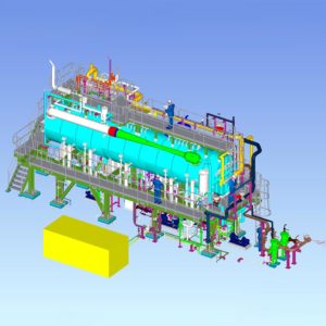
3D Plant surveys and tank digitization
Laser scanner sensors make it possible to capture 3D models of objects at various scales and resolutions, generating high-density point clouds as output. Our integrated approach ensures comprehensive, highly detailed surveys of industrial plants, tanks, and equipment. Thanks to its proven expertise, 3Units offers a full range of targeted services, including:
- Tank digitization for centimeter-accurate calibration charts, deformation monitoring, and verticality analysis
- Creation of georeferenced 3D models integrated with CAD/BIM platforms
- High-precision surveys to support the design, maintenance, and modification of existing facilities
The accuracy and completeness of the captured data enable the development of reliable digital models, supporting a wide variety of industrial applications.

ACCURACY
Industrial deformation analysis and topographic surveys
When millimeter-level precision is essential, laser scanning becomes an indispensable tool. This technology enables accurate deformation analysis of industrial structures, allowing dimensional changes to be monitored with maximum precision.
To meet the diverse needs of both industrial and civil sectors, 3Units offers a wide range of specialized services, including:
- Deformation analysis of tanks, piping systems, and metal structures
- Topographic laser scanning surveys for industrial, commercial, and historical buildings
- Creation of Digital Terrain Models (DTM, DEM, DSM) and orthomosaics
The high quality of the acquired data provides a clear strategic advantage — a solid informational foundation for making informed decisions and carrying out targeted interventions.
INNOVATION
Laser scanning solutions for industry
The 3D point cloud generated through laser scanning unlocks a wide range of possibilities for industrial applications.
Beyond volume calculations and the creation of virtual environments, it is a powerful tool for planning predictive maintenance and analyzing the verticality of tanks and towers.
These are just a few examples of what laser scanning can offer. Its full potential extends across numerous services, including:
- High-speed, high-accuracy volume calculations for complex objects and cut-and-fill analysis in earthworks
- Creation of immersive virtual reality environments for project visualization, personnel training, and operational scenario simulation
- Integration with photogrammetric and ground-penetrating radar (GPR) surveys for complete site digitization — including subsurface mapping and detection of hidden infrastructure
The power of laser scanning, combined with 3Units’ technical expertise, transforms the complexity of industrial plants into detailed, actionable digital models — essential for process optimization, risk prevention, and plant safety.
Discover our case studies

Tavazzano e Montanaso
3Units contributed to the Tavazzano and Montanaso power plant upgrade with advanced 3D modelling, automated workflows and high-precision engineering of 2,500 mechanical supports.
Read the latest news